This has the hallmarks of a secret government or military installation.
Much of it may be deep underground
.
For Interactive Google Earth Version
https://www.google.com.au/maps/@52.0447657,-0.3876788,945m/data=!3m1!1e3
Send Comments HERE
Guesses
Jeff Rense
12-14-16
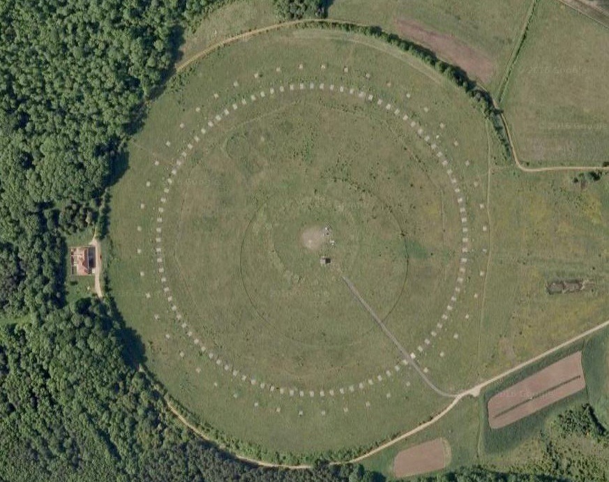
With roads named Mountbatten Way and Nimrod Rd, and
looking at the Chicksands and other structures (they are not homes),
I believe it is a top secret British deep underground military intel
facility. That round item is probably a ULF-microwave transmitting
and receiving antenna array.
From PJ
12-14-16
This is a ground based circular antenna array used to generate high
powered radar and psychotronics
with a Deep Underground Militray Base under all this.
From J.V.
12-14-16
The specific little rectangles in the circle are probably antennas that
can transmtt radar and many other frequencies. The Chinese
were the first to use ground based antennas (close to the ground and
also the first to use strange fractal shapes. See this
Chinese Ground-Based Fractal Antenna System
http://www.pcmag.com/article2/0,2817,2397479,00.asp
From J.N.
12-14-16
This is the remains of a large circular aerial at RAF Chicksands, a
communications centre operated by the
U.S. Air Force, near Shefford, Bedfordshire, England, United Kingdom,
Europe. It was dismantled somewhere between
1999 and 2008. What is seen on google earth images is what is left.
It used to look like this:
http://www.mediastorehouse.com/large-circular-aerial-at-raf-chicksands-a-communications/print/3656409.html
The google earth map locates it as being Chicksands and it is near an
RAF Defense complex